BIENVENIDO

"UN NUEVO MUNDO AL ALCANCE DE UN CLIC"

lunes, 4 de junio de 2012

MADAGASCAR


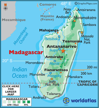
Geografía de Madagascar.-  La isla de Madagascar, la cuarta isla más grande del mundo después de Groenlandia, Nueva Guinea y Borneo, se encuentra situada en el Océano Índico, frente a las costas de Mozambique.
El norte del país, con el macizo de Tsaratanani que alcanza los 2876 mts de altitud, es la región más elevada. El oeste está dominado por una meseta que ve descendiendo hacia el mar. amos la meseta descendiente. El este de la isla está dominada por el macizo de Tsaratanana que llega a 2886 mts en el monte Maromokotro. En el centro y sur las elevaciones principales son las del Ankaratra y Andrigitia
Los ríos, en el este son cortos y torrenciales, mientras que en la parte occidental son más largos aunque sin capacidad de navegación.
El clima tiene bastantes variaciones en función de la altitud y de su relación con el mar. Así, la zona costera en el este tiene un clima con abundantes precipitaciones, mientras que la costa del oeste tiene una larga estación seca. En el sur y suroeste se da un clima semiárido y con escasas precipitaciones, en tanto que en el noroeste las lluvias pueden legar a los 3000 mm anuales. En muchas zonas del interior predomina un clima tropical suavizado por la altitud.


La fiesta más importante en todo el territorio malgache es el 26 de junio cuando se celebra la fiesta de la independencia de Madagascar. Las costumbres de los malgaches, en especial los del centro de la isla, tienen algo en común con las del sur asiático.
Fiestas y feriados
Fecha
Nombre en español
Nombre local
Notas
Año Nuevo
Taom-baovao
El primer día del año es feriado en Madagascar.
Lunes de Pascua
Alatsinain'ny Paska
La Pascua es el primer domingo después de la primera luna llena de primavera.
Conmemoración de los mártires de la sublevación de 1947.
Martioran'ny tolona tamin'ny 1947
Conmemoración de los mártires de la sublevación que sucedió el 27 de marzo de 1947.
Fetin'ny asa
Tradicionalmente el día de muchos acontecimientos políticos y sindicales en Madagascar.
Día de África
Andron'i Afrika
Conmemoración de la creación de la antigua Organización para la Unidad Africana (OUA) 25 de mayo de 1963, que fue reemplazada por la Unión Africana (UA) en 9 de julio de 2002.
El jueves después de 40 días de Pascua
Andro niakarana
Ascensión de Jesucristo a los cielos.
Lunes siguiente al séptimo domingo después de Pascua
Lunes de Pentecostés
Alatsinain'ny Pentekosta
Descenso del Espíritu Santo entre los apóstoles.
Día de la independencia
Fetim-pirenena
Conmemoración de la independencia de la isla de la colonización francesa, el 26 de junio de 1960.
Asompsiona
Asunción de la Virgen María.
Día de todos los santos
Fetin'ny olo-masina
Krismasy
Nacimiento de Jesucristo.


EL LUGAR MAS LEJOS DEL MUNDO!!!!


Centro físico de la Tierra
Dado que la Tierra es casi una esfera, su centro fisco está a miles de kilómetros por debajo de la corteza terrestre, a unos 6371 km, tamaño del radio medio de la Tierra.


Puntos extremos según latitud y longitud
§  Punto más al norte de la Tierra: Polo Norte en el Océano Ártico.


§  Punto más al norte de la Tierra en tierra firme: isla Kaffeklubben, al noreste de Groenlandia (83°40′N 29°50′O), ligeramente al norte del Cabo Morris Jesup en Groenlandia (83°38′N 32°40′O). 


Más al norte se encuentran algunos bancos de piedras, siendo Oodaaq el más conocido.


§  Punto más al sur de la Tierra (también más al sur en tierra firme): Polo Sur, en la Antártida.


§  Puntos más al este y al oeste de la Tierra: basándose en la práctica habitual del uso de la longitud, cualquier lugar a lo largo del meridiano 180º de la Rusia siberiana (que atraviesa isla de Wrangel), la Antártida y tres de las islas Fiyi —península oriental deVanua Levu, mitad de Taveuni y parte occidental de Rabi.)


§  Punto más al oeste de la Tierra en tierra firme: Isla Attu, en Alaska (de acuerdo con la línea internacional de cambio de fecha).


§  Punto más al este de la Tierra en tierra firme: Isla Caroline, en Kiribati (de acuerdo con la línea internacional de cambio de fecha).


domingo, 3 de junio de 2012

NUEVA ZELANDA!!!!


Footprints Waipoua: The spiritual environment of the Waipoua Forest provides a natural stage for an unforgettable encounter with some of the largest Kauri trees remaining in the world.
The powerful spirituality of the Waipoua Forest provides a natural setting for an unforgettable encounter with
 giant trees.  Meet the mighty Te Matua Ngahere ('The Father of the Forest') estimated to be between 3,000 and 4,000 years old, his mighty girth is over 5 metres (15ft) in diameter. 'The Four Sisters' are a graceful collection of kauri trees that have grown close together in sibling harmony and finally, Tane Mahuta ('The Lord of the Forest') who stands an impressive 51 metres (150ft) tall.

Footprints Waipoua offer unique guided forest tour options.


GUIDED TOUR OPTIONS


Meet Tane - day tour:
Suitable for those with limited time or families with young children, This day tour is designed to make your trip into the forest a more memorable and educational experience. You'll meet one of the  local guides at the Tane Mahuta car park in the Waipoua forest for an interactive interpretation of the importance of this tree, Tane Mahuta ('The Lord of the Forest') to both the natural environment and the Maori people. Tour duration is 40 minutes long. Prior arrangement for this option including a meeting time must be made with the Footprints Waipoua office. Tour duration: 40 minutes.

Twilight Encounter:
Setting out from Hokianga by coach, your Maori guide will brief you on the protocols for a visit to the Waipoua Forest.  You'll then be walking under the same stars that guided the legendary Kupe from Hawaiiki to New Zealand and meeting trees that were already giants before his arrival that existed before the birth of Christ.  The highlight of the tour will be a meeting with "The Lord of the Forest" - the giant Tane Mahuta!

Bay of Islands to Hokianga Day Tour:
This tour includes the coach tour to Hokianga, a visit to Tane Mahuta the largest known Kauri tree in the world and an opportunity to experience many of the small communities of historical and cultural significance.  Lunch options are available.  Tour departs at 8.00am and returns to Paihia at 4.00pm.

jueves, 31 de mayo de 2012

TIMBUKTU


The popular statement, " From here to Timbuktu." conjures up images of remote, isolated and distant parts of this earth. Very few people are aware of this ancient city's location, and fewer still ascribe any kind of civilization to this historic area. Timbuktu is located in the western African nation of Mali at the edge of the sahara.
Timbuktu was founded by the Tuareg Imashagan in the 11th century. During the rainy season, the Tuaregs roam the desert up to Arawan in search of grazing lands for their animals. During the dry season, however, they returned to the Niger river where the animals grazed on a grass called "burgu." Whenever they camped by river they got sick from mosquitoes and stagnant water. Because of these unfavorable conditions, they decided to settle few miles away from the river where they dug a well. Whenever it started raining in the desert, the Turareg will leave their heavy goods with an old Tuareg women called Tin Abutut who stayed at the well. In the Tuareg language, Tin Abutut means "the lady with the big naval". With the passage time, the name Tin Abutut became Timbuktu.


The historic town of Timbuktu is located at the precise point where the Niger flows northward into the southern edge of the desert. As a result of its unique geographical position, Timbuktu has been a natural meeting point of Songhai, Wangara,Fulani, Tuareg and Arabs. According to the inhabitants of Timbuku, gold came from the south, the salt from the north and the Divine knowledge, from Timbuktu. Timbuktu is also the cross-road where "the camel met the canoe." It is to this privilege position that the city owes much of its historical dynamism. From the 11th century and onward, Timbuktu became an important port where goods from West Africa and North Africa were traded. 
Goods coming the Mediterranean shores and salt were traded in Timbuktu for gold. The prosperity of the city attracted both black scholars, blacks merchants and Arabs traders from North Africa. Salt, books and gold were very much in demand at that time. Salt was came from Tegaza in the north, gold, from the immense gold mines of the Boure and Banbuk and books, were the refined work of the black scholars and scholars of the Sanhaja descent.
The Tuareg Messufa captured the salt mine of Tegaza and thus took control of the salt trade. The Messufa exported the salt to Timbuktu via camel caravans. This second factor that helps us better explain how the so-called manuscripts of Timbuktu evolved, developed and expanded throughout the whole empire. Thus, the intellectual importance of Timbuktu and the reasons it flourished are not exclusively based upon “strategic position.”   It is important to convey that someone in a position of power was responsible for encouraging the attitude toward learning that prevailed in Timbuktu.As Dr. Molefi Asante has put it so conclusively in his book entitled, Classical Africa.

“The African love for knowledge, literature and learning although now filtered through the religion of Islam, never died. As it has been in the days of the early Egyptian Kingdom, so it was in the days of Askia Mohammed. In fact, Leo Africanus, a historian of the XVIth century wrote about Timbuktu: 
There are many judges, doctors and clerics here, all receiving good salaries from King Askia Mohammed of the State of Songhay. He pays great respect to men of learning. There is a great demand for books, and more profit is made from the trade in books than from any other line of business.”


HAWAI!!!!!!!

Foto de Hawai, Estados Unidos

Caracterizada por su diversidad ecológica y por su escasa población, Big Island es de mayor tamaño que el resto de las islas más conocidas de Hawai juntas. Alquilar un automóvil permite al viajero descubrir los lugares con más encanto de la isla, como las cumbres nevadas de sus montañas, sus bosques tropicales o sus desiertos. Conocida sobre todo por el Parque Nacional de los Volcanes Hawaianos, lugar donde se produjo la erupción volcánica de mayor duración que se haya registrado en toda la historia, Big Island satisface las expectativas tanto de los que persiguen aventuras como de los que buscan el lujo. Estos últimos cuentan con multitud de enormes, aunque algunos ya decadentes, complejos turísticos repartidos por toda la costa de Kohala.

CATEDRALES MAGICAS DE INGLATERRA!!!

Casi todas las catedrales y monasterios de Inglaterra se construyeron sobre "suelo sagrado", ya venerado como lugar de culto por los pobladores prehistóricos del reino insular. Si hoy queremos visitar las antiguas iglesias, en muchos casos no encontraremos más que ruinas en medio de parques asilvestrados. Entre las pocas construcciones que han resistido la decadencia del tiempo están las catedrales de Salisbury (Wiltshire) del siglo XIII y la de St. David (Gales), cuya edificación se inició alrededor de 1180.
La destrucción y desamortización de las propiedades eclesiásticas -y la consiguiente persecución de sacerdotes y monjes- tuvieron lugar durante el reinado de Enrique VIII (1491-1540), quien se rebeló contra el poderoso papa León X (1475-1521), el mismo que excomulgó al reformador Martín Lutero. Para no tener que someterse a la jurisdicción papal, el rey de Inglaterra fundó su propia iglesia, la anglicana, nombrándose él mismo jefe supremo de la misma.


LA LEGENDARIA CASA DE DIOS

La llanura en torno a la antaño floreciente ciudad de Sarum, junto al río Avon, que hoy forma parte del término municipal de Salisbury, es uno de los territorios más cargados de historia de Gran Bretaña. Poblado hace ya más de 7.500 años, apenas otro lugar de las islas británicas ha sido objeto de tanta planificación como New Sarum, que en el siglo XIII sustituyó a Old Sarum, situada tres kilómetros al norte. En el centro de ambas poblaciones había una iglesia. La vieja catedral se hallaba en un sitio húmedo y frío, donde según los testimonios escritos de los monjes pululaban también los espíritus de antiguos moradores.
Cuenta la leyenda que con ánimo de buscar un lugar adecuado para una nueva catedral, un arquero de Old Sarum disparó una flecha. En el lugar en que cayera el proyectil debía surgir el nuevo centro cristiano de Sarum. La flecha se clavó en un ciervo que se arrastró hasta un terreno de la Iglesia antes de caer muerto.
Los habitantes de Old Sarum siguieron a su obispo y construyeron sin interrupción, entre 1220 y 1258, justo en el sitio en que murió el ciervo, la catedral de St. Mary, una de las catedrales inglesas de estilo gótico temprano más nítido. Alrededor de St. Mary, y diseñada en la mesa de dibujo, surgió New Sarum. La construcción del templo, con su torre de 123 m. de altura (la más alta de Inglaterra), resultó muy costosa y solo pudo financiarse gracias a las manufacturas textiles de Salisbury, que en aquel entonces estaban en pleno auge.